| Location |
| City: | | Punta Gorda, Florida, United States |
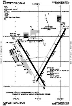
| ICAO / IATA: | KPGD / PGD |
| FAA: | PGD |
Details |
| Type: | Airport (Part 139 Class I) |
| Use: | Public/Civil |
| Latitude: | 26°55'07"N (26.918593) |
| Longitude: | 81°59'27"W (-81.990885) |
| Datum: | WGS 1984 |
| Elevation: | 25 ft (8 m) |
| Runways: | 3 |
| Longest: | 7193 × 150 ft (2192 × 45.5 m) |
Time |
| Timezone: | UTC+29:08 (DST+32:08) |
| Local Time: | |
Weather |
| METAR: | KPGD | 041409Z 00000KT 10SM OVC015 19/16 A3009 RMK AO2 T01940161
|
| TAF: | KPGD | 041122Z 0412/0512 VRB04KT 4SM BR OVC008 TEMPO 0412/0414 1SM BR OVC005
FM041500 04006KT P6SM BKN020
FM041900 30007KT P6SM FEW030 BKN250
FM050200 VRB03KT P6SM FEW050 SCT200
|
Related Locations |
| Nearby: | |
| Farthest: | USL: 11493 mi / 18496 km
Useless Loop, WA, AU |
Find: |
|
Other Information |
Maps:
|
Links:
|
Sources:
|
|