| Location |
| City: | | Palmdale, California, United States |
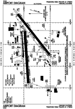
| Name: | Palmdale USAF Plant 42 Airport (Palmdale Regional Airport) |
| ICAO / IATA: | KPMD / PMD |
| FAA: | PMD |
Details |
| Type: | Airport (Airfield) |
| Use: | Public/Civil, Military |
| Latitude: | 34°37'46"N (34.629389) |
| Longitude: | 118°05'04"W (-118.084552) |
| Datum: | WGS 1984 |
| Elevation: | 2542 ft (775 m) |
| Runways: | 3 |
| Longest: | 12002 × 200 ft (3658 × 61 m) |
Time |
| Timezone: | UTC+26:08 (DST+29:08) |
| Local Time: | |
Weather |
| METAR: | KPMD | 041353Z AUTO 25007KT 10SM BKN022 OVC027 08/04 A2975 RMK AO2 RAB17E50 SLP071 P0000 T00830044
|
| TAF: | KPMD | 041146Z 0412/0512 23012KT P6SM -SHRA BKN025 OVC035
FM041500 24025G35KT 6SM -SHRA BR OVC025
FM042300 24028G38KT 5SM -SHRA BR OVC020
FM050600 23022G32KT P6SM -SHRA OVC035
|
Related Locations |
| Nearby: | |
| Farthest: | ZSE: 11434 mi / 18402 km
St-Pierre (St-Pierre de la Réunion) [Pierrefonds], RE |
Find: |
|
Other Information |
Maps:
|
Links:
|
Sources:
|
|