| Location |
| City: | | Seattle, Washington, United States |
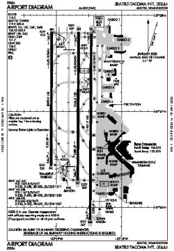
| Name: | Seattle-Tacoma International Airport |
| ICAO / IATA: | KSEA / SEA |
| FAA: | SEA |
Details |
| Type: | Airport (Part 139 Class I) |
| Use: | Public/Civil |
| Latitude: | 47°27'00"N (47.449889) |
| Longitude: | 122°18'42"W (-122.311777) |
| Datum: | WGS 1984 |
| Elevation: | 432 ft (132 m) |
| Runways: | 3 |
| Longest: | 11901 × 150 ft (3627 × 45.5 m) |
Time |
| Timezone: | UTC+26:08 (DST+29:08) |
| Local Time: | |
Weather |
| METAR: | KSEA | 041358Z 36017G25KT 3/4SM R16L/P6000FT -SN BR OVC012 M03/M06 A2953 RMK AO2 P0000 T10331056 $
|
| TAF: | KSEA | 041131Z 0412/0518 36019KT 2SM -SN BR SCT008 BKN012 OVC019 TEMPO 0412/0416 3/4SM -SN BR OVC008
FM041600 36018G24KT 4SM -SN BR BKN012 OVC019
FM041900 36016G23KT P6SM BKN015 OVC025
FM042300 36015G22KT P6SM BKN050
FM050600 04010KT P6SM BKN050
|
Related Locations |
| Nearby: | |
| Farthest: | FAME: 11507 mi / 18518 km
Marion Island, Prince Edward Islands, WC, ZA |
Find: |
|
Other Information |
Maps:
|
Delays:
|
Links:
|
Sources:
|
|