| Location |
| City: | | Sioux City, Iowa, United States |
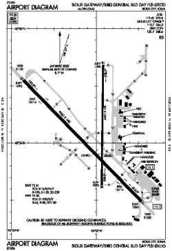
| Name: | Sioux Gateway/Brig General Bud Day Field |
| ICAO / IATA: | KSUX / SUX |
| FAA: | SUX |
Details |
| Type: | Airport (Part 139 Class I) |
| Use: | Public/Civil |
| Latitude: | 42°24'05"N (42.401309) |
| Longitude: | 96°23'04"W (-96.384417) |
| Datum: | WGS 1984 |
| Elevation: | 1098 ft (335 m) |
| Runways: | 2 |
| Longest: | 9002 × 150 ft (2744 × 45.5 m) |
Time |
| Timezone: | UTC+28:08 (DST+31:08) |
| Local Time: | |
Weather |
| METAR: | KSUX | 041352Z 33022G31KT 10SM FEW020 M16/M19 A2998 RMK AO2 PK WND 33034/1319 SNE1259 SLP170 VIS S-SW 7SM P0000 T11611189
|
| TAF: | KSUX | 041132Z 0412/0512 32023G32KT P6SM BKN020
FM041400 32021G29KT P6SM SCT025
FM042000 34015G22KT P6SM SCT200
FM050300 36011KT P6SM BKN180
|
Related Locations |
| Nearby: | |
| Farthest: | YAUG: 10652 mi / 17143 km
Augusta [Augusta Airport], WA, AU |
Find: |
|
Other Information |
Maps:
|
Delays:
|
Links:
|
Sources:
|
|