| Location |
| City: | | Los Angeles, California, United States |
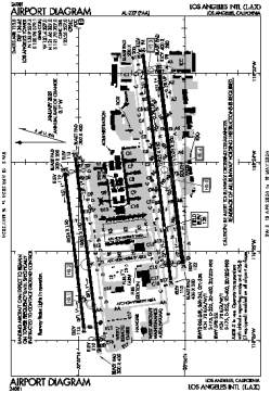
| Name: | Los Angeles International Airport |
| ICAO / IATA: | KLAX / LAX |
| FAA: | LAX |
Details |
| Type: | Airport (Part 139 Class I) |
| Use: | Public/Civil |
| Latitude: | 33°56'33"N (33.942496) |
| Longitude: | 118°24'29"W (-118.408048) |
| Datum: | WGS 1984 |
| Elevation: | 127 ft (39 m) |
| Runways: | 4 |
| Longest: | 12923 × 150 ft (3939 × 45.5 m) |
Time |
| Timezone: | UTC+26:08 (DST+29:08) |
| Local Time: | |
Weather |
| METAR: | KLAX | 041401Z 14007KT 10SM SCT008 BKN026 OVC065 12/09 A2983 RMK AO2 T01220094 $
|
| TAF: | KLAX | 041419Z 0414/0518 14008KT 6SM -SHRA SCT015 OVC025
FM041700 18015G25KT 6SM RA BR OVC015
FM042200 23017G25KT 6SM -RA BR SCT015 OVC025
FM050300 25015KT P6SM -SHRA BKN025 OVC040
FM050700 27015KT P6SM -SHRA SCT025 OVC040
FM051400 15010KT 4SM -RA BR OVC025
|
Related Locations |
| Nearby: | |
| Farthest: | ZSE: 11485 mi / 18484 km
St-Pierre (St-Pierre de la Réunion) [Pierrefonds], RE |
Find: |
|
Other Information |
Maps:
|
Delays:
|
Links:
|
Sources:
|
|