| Location |
| City: | | Columbus, Ohio, United States |
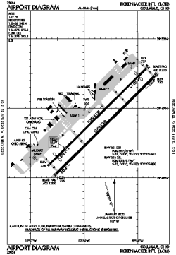
| Name: | Rickenbacker International Airport |
| ICAO / IATA: | KLCK / LCK |
| FAA: | LCK |
Details |
| Type: | Airport (Part 139 Class I) |
| Use: | Public/Civil |
| Latitude: | 39°48'50"N (39.813788) |
| Longitude: | 82°55'40"W (-82.927815) |
| Datum: | WGS 1984 |
| Elevation: | 743 ft (226 m) |
| Runways: | 2 |
| Longest: | 12103 × 200 ft (3689 × 61 m) |
Time |
| Timezone: | UTC+29:08 (DST+32:08) |
| Local Time: | |
Weather |
| METAR: | KLCK | 041415Z AUTO 14004KT 10SM CLR 04/03 A2997 RMK AO2 T00400028
|
| TAF: | KLCK | 041145Z 0412/0512 00000KT P6SM SCT250
FM041500 17012G20KT P6SM FEW025 SCT060
FM042100 19012KT P6SM -RA BKN018 OVC070 TEMPO 0423/0501 5SM -RA
FM050100 21009KT 5SM -RA BR OVC005
FM050700 26009KT 5SM -RA BR OVC005
FM050800 31007KT P6SM OVC008
|
Related Locations |
| Nearby: | |
| Farthest: | YAUG: 11375 mi / 18307 km
Augusta [Augusta Airport], WA, AU |
Find: |
|
Other Information |
Maps:
|
Links:
|
Sources:
|
|