| Location |
| City: | | Long Beach, California, United States |
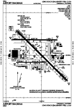
| Name: | Long Beach Airport (Daugherty Field) |
| ICAO / IATA: | KLGB / LGB |
| FAA: | LGB |
Details |
| Type: | Airport (Part 139 Class I) |
| Use: | Public/Civil |
| Latitude: | 33°49'05"N (33.817930) |
| Longitude: | 118°09'07"W (-118.151890) |
| Datum: | WGS 1984 |
| Elevation: | 60 ft (18 m) |
| Runways: | 3 |
| Longest: | 10000 × 200 ft (3048 × 61 m) |
Time |
| Timezone: | UTC+26:08 (DST+29:08) |
| Local Time: | |
Weather |
| METAR: | KLGB | 041353Z AUTO 00000KT 10SM BKN075 12/10 A2984 RMK AO2 RAE42 SLP103 P0000 T01220100
|
| TAF: | KLGB | 041146Z 0412/0512 15006KT 6SM -SHRA SCT015 OVC040
FM041500 16015KT 6SM -SHRA SCT015 OVC035
FM041900 18018G25KT 4SM RA BR OVC015
FM042300 23017G25KT 5SM -RA BR SCT015 OVC025
FM050400 25015KT P6SM -SHRA BKN025 OVC040
FM050800 27015KT P6SM -SHRA SCT025 OVC040
|
Related Locations |
| Nearby: | |
| Farthest: | ZSE: 11487 mi / 18486 km
St-Pierre (St-Pierre de la Réunion) [Pierrefonds], RE |
Find: |
|
Other Information |
Maps:
|
Delays:
|
Links:
|
Sources:
|
|