| Location |
| City: | | Sacramento, California, United States |
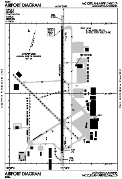
| Name: | McClellan Airfield |
| ICAO / IATA: | KMCC / MCC |
| FAA: | MCC |
Details |
| Type: | Airport (Airfield) |
| Use: | Public/Civil |
| Latitude: | 38°40'04"N (38.667639) |
| Longitude: | 121°24'02"W (-121.400610) |
| Datum: | WGS 1984 |
| Elevation: | 76 ft (23 m) |
| Runways: | 1 |
| Longest: | 10599 × 150 ft (3231 × 45.5 m) |
Time |
| Timezone: | UTC+26:08 (DST+29:08) |
| Local Time: | |
Weather |
| METAR: | KMCC | 041415Z AUTO 16016G22KT 7SM BKN026 OVC032 09/08 A2951 RMK AO2
|
| TAF: | KMCC | 041132Z 0412/0512 15017G25KT 5SM -SHRA SCT015 OVC035 TEMPO 0412/0416 2SM SHRA BKN015
FM041700 19014G23KT P6SM -SHRA OVC050
FM050200 16008KT P6SM -SHRA OVC050
|
Related Locations |
| Nearby: | |
| Farthest: | FTU: 11275 mi / 18145 km
Tolagnaro [Maurillac Airport (Fort Dauphin Airport)], MG |
Find: |
|
Other Information |
Maps:
|
Links:
|
Sources:
|
|