| Location |
| City: | | Montgomery, Alabama, United States |
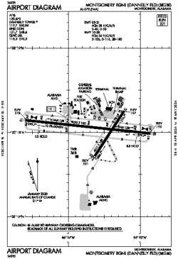
| Name: | Montgomery Regional (Dannelly Field) |
| ICAO / IATA: | KMGM / MGM |
| FAA: | MGM |
Details |
| Type: | Airport (Part 139 Class I) |
| Use: | Public/Civil |
| Latitude: | 32°18'02"N (32.300639) |
| Longitude: | 86°23'38"W (-86.393971) |
| Datum: | WGS 1984 |
| Elevation: | 221 ft (67 m) |
| Runways: | 2 |
| Longest: | 9020 × 150 ft (2749 × 45.5 m) |
Time |
| Timezone: | UTC+28:08 (DST+31:08) |
| Local Time: | |
Weather |
| METAR: | KMGM | 041353Z 00000KT 1/4SM FG OVC002 12/12 A3008 RMK AO2 SLP186 T01170117
|
| TAF: | KMGM | 041128Z 0412/0512 08003KT 2SM BR BKN002 TEMPO 0412/0415 1/4SM FG VV002
FM041500 15005KT 5SM BR OVC007
FM041800 17006KT P6SM OVC020
FM050300 VRB03KT 5SM BR OVC008
FM050600 VRB02KT 2SM BR BCFG OVC006
|
Related Locations |
| Nearby: | |
| Farthest: | MQZ: 11195 mi / 18017 km
Margaret River [Margaret River Airport], WA, AU |
Find: |
|
Other Information |
Maps:
|
Delays:
|
Links:
|
Sources:
|
|