| Location |
| City: | | Milwaukee, Wisconsin, United States |
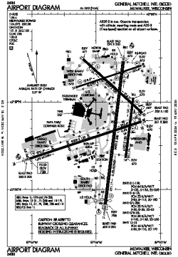
| Name: | General Mitchell International Airport |
| ICAO / IATA: | KMKE / MKE |
| FAA: | MKE |
Details |
| Type: | Airport (Part 139 Class I) |
| Use: | Public/Civil |
| Latitude: | 42°56'49"N (42.946932) |
| Longitude: | 87°53'49"W (-87.897063) |
| Datum: | WGS 1984 |
| Elevation: | 728 ft (222 m) |
| Runways: | 5 |
| Longest: | 9990 × 200 ft (3045 × 61 m) |
Time |
| Timezone: | UTC+28:08 (DST+31:08) |
| Local Time: | |
Weather |
| METAR: | KMKE | 041352Z 21009KT 7SM SCT037 BKN065 OVC100 07/06 A2963 RMK AO2 SLP036 T00720056
|
| TAF: | KMKE | 041254Z 0413/0518 21009KT 6SM BR VCSH SCT025 BKN090
FM041500 21010KT 6SM -RA BKN025
FM041900 25011KT P6SM VCSH OVC005
FM042100 28011G19KT P6SM BKN015
FM050400 31010KT P6SM SCT050
|
Related Locations |
| Nearby: | |
| Farthest: | YAUG: 11064 mi / 17807 km
Augusta [Augusta Airport], WA, AU |
Find: |
|
Other Information |
Maps:
|
Delays:
|
Links:
|
Sources:
|
|