| Location |
| City: | | New Orléans, Louisiana, United States |
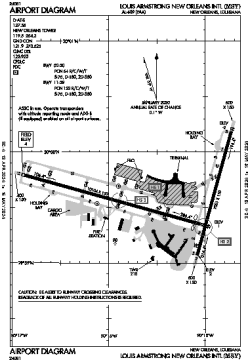
| Name: | Louis Armstrong New Orléans International (Moisant Field) |
| ICAO / IATA: | KMSY / MSY |
| FAA: | MSY |
Details |
| Type: | Airport (Part 139 Class I) |
| Use: | Public/Civil |
| Latitude: | 29°59'36"N (29.993278) |
| Longitude: | 90°15'32"W (-90.259027) |
| Datum: | WGS 1984 |
| Elevation: | 3 ft (1 m) |
| Runways: | 2 |
| Longest: | 10104 × 150 ft (3080 × 45.5 m) |
Time |
| Timezone: | UTC+28:08 (DST+31:08) |
| Local Time: | |
Weather |
| METAR: | KMSY | 041353Z 00000KT 1 3/4SM BR OVC006 18/18 A3001 RMK AO2 SLP166 T01780178
|
| TAF: | KMSY | 041329Z 0413/0518 13003KT 1 1/2SM BR SCT003 BKN010 OVC015 TEMPO 0413/0415 3/4SM BR OVC002
FM041500 VRB04KT 3SM -SHRA BR OVC009
FM050600 VRB03KT 1/2SM FG OVC002
FM051000 00000KT 2SM BR OVC004
FM051700 VRB03KT 2SM -SHRA BR BKN027
|
Related Locations |
| Nearby: | |
| Farthest: | CCK: 11125 mi / 17904 km
West Island (Pulau Panjang) [Cocos (Keeling) Islands], CC |
Find: |
|
Other Information |
Maps:
|
Delays:
|
Links:
|
Sources:
|
|