| Location |
| City: | | Omaha, Nebraska, United States |
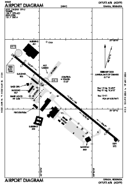
| Name: | Offutt AFB |
| ICAO / IATA: | KOFF / OFF |
| FAA: | OFF |
Details |
| Type: | Airport (Airfield) |
| Use: | Military |
| Latitude: | 41°07'10"N (41.119329) |
| Longitude: | 95°54'31"W (-95.908516) |
| Datum: | WGS 1984 |
| Elevation: | 1048 ft (319 m) |
| Runways: | 1 |
| Longest: | 11703 × 150 ft (3567 × 45.5 m) |
Time |
| Timezone: | UTC+28:08 (DST+31:08) |
| Local Time: | |
Weather |
| METAR: | KOFF | 041356Z AUTO 30012KT 10SM BKN005 OVC016 M10/M11 A2995 RMK AO2 PK WND 30027/12 SNB41E49 SLP159 P0000 T11051107 $
|
| TAF: | KOFF | 041000Z 0410/0516 32015G25KT 6000 BR OVC010 620102 QNH2975INS BECMG 0411/0412 33015G25KT 9999 NSW OVC015 620152 QNH2980INS BECMG 0416/0417 33015G25KT 9999 SCT020 QNH2988INS BECMG 0423/0424 35012KT 9999 SCT100 QNH3000INS BECMG 0511/0512 02009KT 9999 SCT050 BKN080 QNH3005INS TXM05/0418Z TNM08/0510Z
|
Related Locations |
| Nearby: | |
| Farthest: | YAUG: 10687 mi / 17199 km
Augusta [Augusta Airport], WA, AU |
Find: |
|
Other Information |
Maps:
|
Links:
|
Sources:
|
|