| Location |
| City: | | Chicago, Illinois, United States |
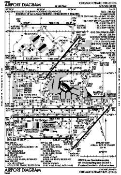
| Name: | Chicago O'Hare International Airport |
| ICAO / IATA: | KORD / ORD |
| FAA: | ORD |
Details |
| Type: | Airport (Part 139 Class I) |
| Use: | Public/Civil |
| Latitude: | 41°58'37"N (41.976940) |
| Longitude: | 87°54'29"W (-87.908149) |
| Datum: | WGS 1984 |
| Elevation: | 680 ft (207 m) |
| Runways: | 8 |
| Longest: | 13000 × 150 ft (3962 × 45.5 m) |
Time |
| Timezone: | UTC+28:08 (DST+31:08) |
| Local Time: | |
Weather |
| METAR: | KORD | 041351Z 18009KT 10SM BKN035 BKN045 OVC070 09/07 A2967 RMK AO2 SLP049 T00940072
|
| TAF: | KORD | 041130Z 0412/0518 19012G17KT P6SM SCT015 BKN040 WS015/22040KT TEMPO 0413/0415 5SM -SHRA BR BKN015
FM041500 20013G20KT 4SM -SHRA BR SCT006 OVC010 WS020/23040KT TEMPO 0415/0419 1 1/2SM -SHRA BR OVC006
FM042000 27013G20KT P6SM SCT008 BKN010 OVC040
FM050100 30013G20KT P6SM SCT025
FM050900 32009KT P6SM SCT250
FM051300 03010KT P6SM BKN035
|
Related Locations |
| Nearby: | |
| Farthest: | YAUG: 11084 mi / 17837 km
Augusta [Augusta Airport], WA, AU |
Find: |
|
Other Information |
Maps:
|
Delays:
|
Links:
|
Sources:
|
|