| Location |
| City: | | Oslo, Akershus, Norway |
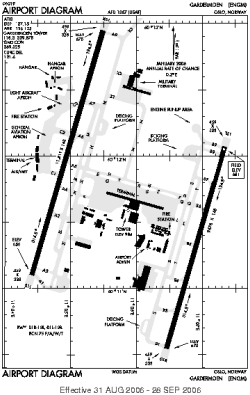
| Name: | Oslo Airport Gardermoen |
| ICAO / IATA: | ENGM / OSL |
Details |
| Type: | Airport (Aerodrome, Airfield) |
| Use: | Public/Civil, Military |
| Latitude: | 60°11'38"N (60.193917) |
| Longitude: | 11°06'01"E (11.100361) |
| Datum: | WGS 1984 |
| Elevation: | 681 ft (208 m) |
| Runways: | 2 |
| Longest: | 11811 × 148 ft (3600 × 45 m) |
Time |
| Timezone: | UTC+1 (DST+4) |
| Local Time: | |
Weather |
| METAR: | ENGM | 041420Z 00000KT 1700 -SN BR SCT011 OVC013 M11/M12 Q1012 TEMPO 1200 SN VV005
|
| TAF: | ENGM | 041100Z 0412/0512 01005KT 7000 -SN SCT003 BKN012 TEMPO 0413/0509 1400 SN BR VV003 BECMG 0505/0507 SCT005 BKN020
|
Related Locations |
| Nearby: | |
| Farthest: | CHT: 11254 mi / 18112 km
Waitangi [Tuuta], CIT, NZ |
Find: |
|
Other Information |
Maps:
|
Sources:
|
|