| Location |
| City: | | Ottumwa, Iowa, United States |
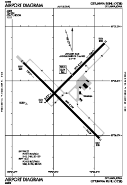
| Name: | Ottumwa Regional |
| ICAO / IATA: | KOTM / OTM |
| FAA: | OTM |
Details |
| Type: | Airport (Airfield) |
| Use: | Public/Civil |
| Latitude: | 41°06'26"N (41.107222) |
| Longitude: | 92°26'50"W (-92.447166) |
| Datum: | WGS 1984 |
| Elevation: | 845 ft (258 m) |
| Runways: | 2 |
| Longest: | 6001 × 100 ft (1829 × 30.5 m) |
Time |
| Timezone: | UTC+28:08 (DST+31:08) |
| Local Time: | |
Weather |
| METAR: | KOTM | 041353Z AUTO 31015KT 10SM OVC007 01/M01 A2973 RMK AO2 PK WND 30029/1300 CIG 005V011 SLP073 T00061006
|
| TAF: | KOTM | 041136Z 0412/0512 19010KT 6SM -DZ BR SCT015 OVC035
FM041245 31015G25KT P6SM OVC007 TEMPO 0413/0415 4SM -DZ BR OVC004
FM041530 31017G27KT P6SM BKN014 OVC030
FM041800 31016G25KT P6SM FEW035 SCT150
FM042300 32015KT P6SM SCT250
|
Related Locations |
| Nearby: | |
| Farthest: | YAUG: 10866 mi / 17488 km
Augusta [Augusta Airport], WA, AU |
Find: |
|
Other Information |
Maps:
|
Links:
|
Sources:
|
|