| Location |
| City: | | Pocatello, Idaho, United States |
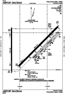
| Name: | Pocatello Regional |
| ICAO / IATA: | KPIH / PIH |
| FAA: | PIH |
Details |
| Type: | Airport (Part 139 Class I) |
| Use: | Public/Civil |
| Latitude: | 42°54'35"N (42.909793) |
| Longitude: | 112°35'45"W (-112.595918) |
| Datum: | WGS 1984 |
| Elevation: | 4451 ft (1357 m) |
| Runways: | 2 |
| Longest: | 9059 × 150 ft (2761 × 45.5 m) |
Time |
| Timezone: | UTC+27:08 (DST+30:08) |
| Local Time: | |
Weather |
| METAR: | KPIH | 041353Z 18012KT 9SM -SN OVC055 01/00 A2953 RMK AO2 UPB08E09SNB09 SLP006 P0000 T00110000
|
| TAF: | KPIH | 041120Z 0412/0512 24011KT 4SM -RASN BR BKN015 OVC030 TEMPO 0412/0415 2SM -SN BR SCT007 OVC015
FM041500 18010KT 6SM -RASN BR SCT015 OVC030
FM041900 16012KT P6SM -SHRA SCT030 BKN045
FM050200 17010KT 6SM -SHRA BKN020 OVC035
FM050600 18012KT P6SM VCSH SCT015 BKN060
|
Related Locations |
| Nearby: | |
| Farthest: | FAME: 10973 mi / 17659 km
Marion Island, Prince Edward Islands, WC, ZA |
Find: |
|
Other Information |
Maps:
|
Delays:
|
Links:
|
Sources:
|
|