| Location |
| City: | | Pittsburgh, Pennsylvania, United States |
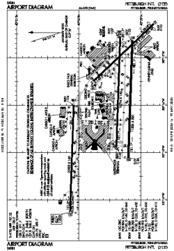
| Name: | Pittsburgh International Airport |
| ICAO / IATA: | KPIT / PIT |
| FAA: | PIT |
Details |
| Type: | Airport (Part 139 Class I) |
| Use: | Public/Civil |
| Latitude: | 40°29'29"N (40.491417) |
| Longitude: | 80°13'58"W (-80.232693) |
| Datum: | WGS 1984 |
| Elevation: | 1202 ft (366 m) |
| Runways: | 4 |
| Longest: | 11500 × 200 ft (3505 × 61 m) |
Time |
| Timezone: | UTC+29:08 (DST+32:08) |
| Local Time: | |
Weather |
| METAR: | KPIT | 041351Z 00000KT 10SM BKN250 02/01 A3002 RMK AO2 SLP180 T00170011
|
| TAF: | KPIT | 041134Z 0412/0518 17004KT P6SM SCT250
FM042300 18008KT P6SM BKN050
FM050200 21008KT 6SM -RA BKN025 WS020/22040KT
FM050700 21006KT 5SM -RA OVC010 WS020/24040KT
FM051300 28006KT P6SM OVC010
|
Related Locations |
| Nearby: | |
| Farthest: | YAUG: 11495 mi / 18499 km
Augusta [Augusta Airport], WA, AU |
Find: |
|
Other Information |
Maps:
|
Delays:
|
Links:
|
Sources:
|
|