| Location |
| City: | | Chicago/Rockford, Illinois, United States |
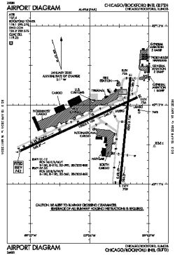
| Name: | Chicago/Rockford International Airport |
| ICAO / IATA: | KRFD / RFD |
| FAA: | RFD |
Details |
| Type: | Airport (Part 139 Class I) |
| Use: | Public/Civil |
| Latitude: | 42°11'43"N (42.195361) |
| Longitude: | 89°05'50"W (-89.097221) |
| Datum: | WGS 1984 |
| Elevation: | 742 ft (226 m) |
| Runways: | 2 |
| Longest: | 10002 × 150 ft (3049 × 45.5 m) |
Time |
| Timezone: | UTC+28:08 (DST+31:08) |
| Local Time: | |
Weather |
| METAR: | KRFD | 041416Z 18009KT 4SM R01/6000VP6000FT -RA BR FEW021 BKN025 OVC043 05/04 A2966 RMK AO2 P0001 T00500044
|
| TAF: | KRFD | 041130Z 0412/0512 19011KT 5SM BR SCT015 OVC035 WS015/22035KT TEMPO 0412/0414 2SM -SHRA BKN015
FM041400 20013G20KT 3SM -SHRA BR SCT005 OVC010 WS020/23035KT TEMPO 0414/0418 1SM -SHRA BR OVC005
FM041900 26013G20KT P6SM BKN008 OVC030
FM042300 29013G20KT P6SM SCT025
FM050600 32009KT P6SM SCT250
|
Related Locations |
| Nearby: | |
| Farthest: | YAUG: 11021 mi / 17736 km
Augusta [Augusta Airport], WA, AU |
Find: |
|
Other Information |
Maps:
|
Delays:
|
Links:
|
Sources:
|
|