| Location |
| City: | | Sarasota/Bradenton, Florida, United States |
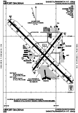
| Name: | Sarasota/Bradenton International Airport |
| ICAO / IATA: | KSRQ / SRQ |
| FAA: | SRQ |
Details |
| Type: | Airport (Part 139 Class I) |
| Use: | Public/Civil |
| Latitude: | 27°23'44"N (27.395444) |
| Longitude: | 82°33'16"W (-82.554388) |
| Datum: | WGS 1984 |
| Elevation: | 29 ft (9 m) |
| Runways: | 2 |
| Longest: | 9500 × 150 ft (2896 × 45.5 m) |
Time |
| Timezone: | UTC+29:08 (DST+32:08) |
| Local Time: | |
Weather |
| METAR: | KSRQ | 041418Z 07005KT 10SM OVC015 19/17 A3006 RMK AO2 T01940172
|
| TAF: | KSRQ | 041122Z 0412/0512 VRB03KT 4SM BR SCT003 OVC010 TEMPO 0412/0414 1SM BR OVC003
FM041500 07006KT P6SM BKN015
FM041800 30008KT P6SM FEW025 BKN200
FM050200 VRB03KT P6SM FEW050 SCT200
|
Related Locations |
| Nearby: | |
| Farthest: | USL: 11458 mi / 18439 km
Useless Loop, WA, AU |
Find: |
|
Other Information |
Maps:
|
Delays:
|
Links:
|
Sources:
|
|