| Location |
| City: | | Moosonee, Ontario, Canada |
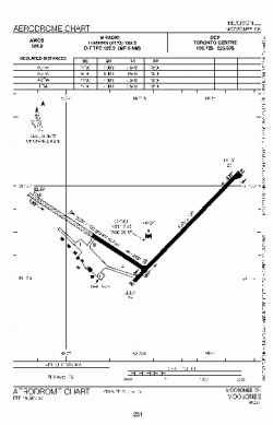
| Name: | Moosonee Airport |
| ICAO / IATA: | CYMO / YMO |
Details |
| Type: | Airport (Airfield) |
| Use: | Public/Civil |
| Latitude: | 51°17'31"N (51.291944) |
| Longitude: | 80°36'30"W (-80.608332) |
| Elevation: | 30 ft (9 m) |
| Runways: | 2 |
| Longest: | 4004 ft (1220 m) |
Time |
| Timezone: | UTC+29:08 (DST+32:08) |
| Local Time: | |
Weather |
| METAR: | CYMO | 041400Z AUTO 29005KT 9SM CLR M27/M30 A3025 RMK SLP247
|
| TAF: | CYMO | 041139Z 0412/0424 32010KT P6SM BKN150
FM041600 31010KT P6SM BKN050 TEMPO 0416/0422 5SM -SN BKN020 BECMG 0418/0420 04010KT
FM042200 03010KT 1SM -SN OVC015 RMK FCST BASED ON AUTO OBS. NXT FCST BY 041800Z
|
Related Locations |
| Nearby: | |
| Farthest: | YCSK: 11319 mi / 18217 km
Casey Station [Casey Station Skiway], Wilkes Land, AQ |
Find: |
|
Other Information |
Maps:
|
Sources:
|
|